| TAMU Image Gallery | GOOGLE (Quercus agrifolia) |
| 19 IMAGES FOUND AT PLANTSYSTEMATICS.ORG: IMAGES 1 - 19: | |||||||
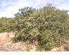
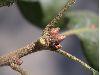
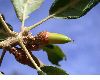 Quercus agrifolia |  Quercus agrifolia |  Quercus agrifolia | 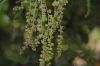 Quercus agrifolia |  Quercus agrifolia | 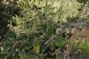 Quercus agrifolia |  Quercus agrifolia | 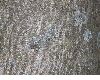 Quercus agrifolia |
 Quercus agrifolia | 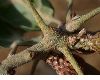 Quercus agrifolia | 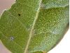 Quercus agrifolia | 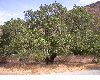 Quercus agrifolia | 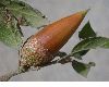 Quercus agrifolia | 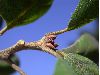 Quercus agrifolia | 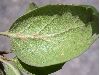 Quercus agrifolia | 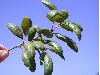 Quercus agrifolia |
 Quercus agrifolia | 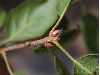 Quercus agrifolia | 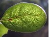 Quercus agrifolia | |||||
67 SPECIMENS OF Quercus agrifolia from MULLER OAK DATABASE (this list is incomplete):
| NA | Mexico: Baja California Norte: : beside highway, 11 mi NW of Ensenada, 2 Jan 1948, Dixon 345 (BH-CHM); |
| NA | Mexico: Baja California Norte: : Mesa Redonda, Tijuana, January 1952, Preciado 2330 (BH-CHM); |
| NA | Mexico: Baja California Norte: : Mesa Redonda, Tijuana, January 1952, Preciado 2331 (BH-CHM); |
| 6774 | Mexico: Baja California Norte: : Sierra de San Martir; grade between El Pinonal and El Portrerito, 16 Aug 1960, Muller 10896 (BH-CHM); |
| NA | Mexico: Baja California Norte: Mun. Ensenada : Grade between El Pinonal and El Portrerito, about El Portrerito; Sierra de San Martir, 16 Aug 1960, Muller 10898 (BH-CHM); |
| NA | USA: California: : without locality, 25 Mar 1964, Elfving (BH-CHM); |
| NA | USA: California: : Napa River Basin, Sr. Helena, 17 Nov 1901, Jepson 1754 (BH-CHM); |
| NA | USA: California: : Van Arsdale Ranch, Walker Valley Region, 3-5 July 1903, Jepson 2191 (BH-CHM); |
| NA | USA: California: Alameda County : Beside Skyline Drive, 1 mi S of Fish Ranch Road, Oakland Hills, 29 Aug 1941, Tucker 388 (BH-CHM); |
| NA | USA: California: Contra Costa County : Oakland hills, 100 yards NW of intersection of Grizzly Peak Boulevard and road to Eastport, 4 Apr 1946, Tucker 1391 (BH-CHM); |
| NA | USA: California: Contra Costa County : old Cowell Ranch, Ygnacio Valley, 25 Mar 1964, Elfving 23 (BH-CHM); |
| NA | USA: California: Contra Costa County : Redwood Peak, 150 yards S of summit, 14 Mar 1946, Tucker 1374 (BH-CHM); |
| NA | USA: California: Contra Costa County : Redwood Peak, 200 yards S of summit, 14 Mar 1946, Tucker 1375 (BH-CHM); |
| NA | USA: California: Contra Costa County : S side of San Joaquin River, just E of Antioch, 4 Mar 1959, Burns (BH-CHM); |
| NA | USA: California: El Dorado County : Diamond Springs, 12 Apr 1938, Jepson 18640 (BH-CHM); |
| NA | USA: California: Los Angeles County : Beverly Hills Hollywood, 10 Aug 1937, Muller 2504 (BH-CHM); |
| NA | USA: California: Los Angeles County : Flintridge, hills above Devil's Gate Dam, in arroyo seco., 26 Aug 1937, Muller 2515 (BH-CHM); |
| NA | USA: California: Los Angeles County : Piru Creek, 7 mi S of Caswell, 15 mi N of Castaic, 20 Mar 1945, Muller 5251 (BH-CHM); |
| NA | USA: California: Los Angeles County : Piru Creek, 7 mi S of Caswell, 15 mi n of Castaici NE of Ojai, 20 Mar 1945, Muller 5251 (BH-CHM); |
| NA | USA: California: Marin County : on Harry Allen Trail, 0.1 mi E of Phoenix Lake Dam, 0.5 mi SW of Ross, 25 Apr 1964, Lang 27 (BH-CHM); |
| NA | USA: California: Marin County : Upper rim of Deer Park on alpine Lake Trail, 8 Mar 1936, Ewan 9407 (BH-CHM); |
| NA | USA: California: Mendocino County : Ukiah Valley, E side opposite Large Station, 15 Oct 1922, Tracy 6130 (BH-CHM); |
| NA | USA: California: Monterey County : 1 12 mi E of Bad Gulch, inland from Big Sur, beside Pine Ridge Trail, 8 Aug 1946, Tucker 1396 (BH-CHM); |
| NA | USA: California: Monterey County : Sta. Lucia Mts.: Arroyo Seco, 2 mi above Memorial Park, 1 mi below Madrone Camp, 18 Jun 1954, Muller 9619 (BH-CHM); |
| NA | USA: California: Monterey County : U. of California Hastings Wild Life Reserve, 5 Oct 1941, Tucker 418 (BH-CHM); |
| NA | USA: California: Napa County : roadside, W side of "Silverado Trail", 2.3 mi NW of intersection with Hwy 28, (Rutherford-Conn Dam R, 25 Oct 1953, Tucker 2693 (BH-CHM); |
| NA | USA: California: Riverside County : E side of San Jacinto Mts., 18 mi SE of Keen Camp, 10 Aug 1941, Muller 4045 (BH-CHM); |
| NA | USA: California: Riverside County : Gavilan Peak, 15 Apr 1930, Clokey & Clokey 4735 (BH-CHM); |
| NA | USA: California: Riverside County : Pinyon Flats, Sta. Rosa Mts, 3 Oct 1948, Neely 305 (BH-CHM); |
| NA | USA: California: San Diego County : 1 mi N of Lake Hodes, 8 Aug 1941, Muller 4020 (BH-CHM); |
| NA | USA: California: San Diego County : 5 mi S of Morettis toward Santa Ysabel, 9 Aug 1941, Muller 4035 (BH-CHM); |
| NA | USA: California: San Diego County : Doane Valley, Palamar Mt., 9 Aug 1941, Muller 4028 (BH-CHM); |
| NA | USA: California: San Diego County : N. Boulevard, 23 Nov 1930, Hood (BH-CHM); |
| NA | USA: California: San Diego County : Oak Grove, 5 June 1932, Fosberg 8267 (BH-CHM); |
| NA | USA: California: San Diego County : Slopes about Lake Henshaw, 9 Aug 1941, Muller 4033 (BH-CHM); |
| NA | USA: California: San Mateo County : Jasper ridge, Stanford Biological Reserve, 10 m from permanent spring below, 10 Apr 1960, Dengler 10 (BH-CHM); |
| NA | USA: California: Santa Barbara County : Above Lady's Harbor, Santa Cruz Island, 8 Jun 1951, Muller 8961 (BH-CHM); |
| NA | USA: California: Santa Barbara County : Canyon above prisoners Harbor, Santa Cruz Island, 23 Mar 1932, Fosberg 7687 (BH-CHM); |
| NA | USA: California: Santa Barbara County : Mountain Dr. below Tremonto Rd., 5 Aug 1941, Muller 4002 (BH-CHM); |
| NA | USA: California: Santa Barbara County : Prisoners harbor, Santa Cruz Island, 6 Mar 1932, Fosberg 7573 (BH-CHM); |
| NA | USA: California: Santa Barbara County : Prisoners Harbor, Santa Cruz Island, 6 Mar 1932, Fosberg 7628 (BH-CHM); |
| NA | USA: California: Santa Barbara County : Prisoners harbor, Santa Cruz Island, just above lower ranch, 23 Mar 1932, Fosberg 7600a (BH-CHM); |
| NA | USA: California: Santa Barbara County : Rattlesnake Canyon road to Skofield Ranch, 30 Oct 1938, Kinsel 49 (BH-CHM); |
| NA | USA: California: Santa Barbara County : Rattlesnake Canyon road to Skofield Ranch, 30 Oct 1938, Kinsel 47 (BH-CHM); |
| NA | USA: California: Santa Barbara County : Santa Cruz Island, 12 mi upstream from the mouth of Coches Prieto Canyon on W sode of Canyon, 1 May 1960, Blakley 3374 (BH-CHM); |
| NA | USA: California: Santa Barbara County : Santa Cruz Island, above Lady's Harbor, 8 Jun 1951, Muller 8962 (BH-CHM); |
| NA | USA: California: Santa Barbara County : Santa Cruz Island, Christy Canyon, slopes of S ridge, 26 Apr 1947, Muller 8846 (BH-CHM); |
| NA | USA: California: Santa Barbara County : Santa Cruz Island, Cn. del Puerto 1 mi NE of Stanton Ranch Hdq., 11 Oct 1958, Blakley & Balls B-2496 (BH-CHM); |
| NA | USA: California: Santa Barbara County : Santa Cruz Island, E of Pelican Bay, 1 Sep 1930, Clokey 4898 (BH-CHM); |
| NA | USA: California: Santa Barbara County : Santa Cruz Island, North side, above Pelican Bay, 25 Jun 1951, Muller 8944 (BH-CHM); |
| NA | USA: California: Santa Barbara County : Santa Cruz Island, Pelican Bay, 31 Aug 1930, Clokey 4888 (BH-CHM); |
| NA | USA: California: Santa Barbara County : Santa Cruz Island, Pelican Bay, near mouth, Aug 1930, Clokey 4895 (BH-CHM); |
| NA | USA: California: Santa Barbara County : Santa Cruz Island, pine grove on point at lower end of pine stand above China Harbor, 24 Jul 1960, Muller 10876 (BH-CHM); |
| NA | USA: California: Santa Barbara County : Santa Cruz Island, Ridge S of Cn. del Medio 3 12 mi W of Stanton Ranch Hdq., 11 Oct 1958, Blakley & Balls B-2514 (BH-CHM); |
| NA | USA: California: Santa Barbara County : Santa Rosa Island, Cherry Canyon, 1 mi above the ranchs Springs, 10 mi NE of Ojai, 5 Apr 1960, Muller 10751 (BH-CHM); |
| NA | USA: California: Santa Barbara County : Santa Rosa Island, Torrey Pine Grove, bottom at the head of a small canyon, 5-10 Apr 1960, Blakley & Smith 3101 (BH-CHM); |
| NA | USA: California: Santa Barbara County : Sta. Rosa Island: Cherry Canyon, 30 May 1938, Kinsel 5 (BH-CHM); |
| NA | USA: California: Santa Barbara County : Sta. Rosa Island: Cherry Canyon, 30 May 1938, Kinsel 7 (BH-CHM); |
| NA | USA: California: Santa Barbara County : Sta. Rosa Island: Cherry Canyon, 1 mi above the ranch, 5 Apr 1960, Muller 10755 (BH-CHM); |
| NA | USA: California: Solano County : Araquipa Hills, 29 Dec 1898, Jepson (BH-CHM); |
| NA | USA: California: Solano County : Lagoon Valley, Sept 1903, Platt (BH-CHM); |
| NA | USA: California: Ventura County : 1 14 mi NW of Casitas, 25 Jan 1934, Soivder 3973 (BH-CHM); |
| NA | USA: California: Ventura County : Camp Comfort, Ojai Valley, 18 Apr 1932, Fosberg 7999 (BH-CHM); |
| NA | USA: California: Ventura County : Santa Clara River, E of Santa Paula, 27 Aug 1937, Muller 2519 (BH-CHM); |
| NA | USA: California: Ventura County : Wheeler's Gorge, 2 mi above Wheelers Springs, 10 mi NE of Ojai, 19 Mar 1945, Muller 5217 (BH-CHM); |
| NA | USA: California: Ventura County : Wheelers Gorge, 2 mi above Wheelers Springs, 10 mi NE of Ojai, 19 Mar 1945, Muller 5217 (BH-CHM); |
| NA | USA: California: Yolo County : Davis, University of California Campus, Howard Ave., 25 Mar 1959, Shellhammer 16 (BH-CHM); |
COUNTY MAPPER
| NUMBER OF GENERA IN Fagaceae: 8 | KEW LIST: Fagaceae |
| Castanea | Castanopsis | Chrysolepis | Fagus | Formanodendron | Lithocarpus | Quercus 19 | Trigonobalanus |