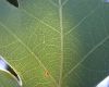
| TAMU Image Gallery | GOOGLE (Quercus alba) |
| 6 IMAGES FOUND AT PLANTSYSTEMATICS.ORG: IMAGES 1 - 6: | |||||||
 Quercus alba | 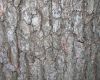 Quercus alba | 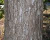 Quercus alba | 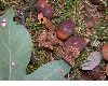 Quercus alba |  Quercus alba |  Quercus alba | ||
36 SPECIMENS OF Quercus alba from MULLER OAK DATABASE (this list is incomplete):
| NA | USA: Arkansas: Clay County : P.O. Piggott, 12 Aug 1955, Demaree 37845 (BH-CHM); |
| NA | USA: Arkansas: Craighead County : P.O. Jonesboro, Crowleys Ridge, 4 Oct 1951, Demaree 31486 (BH-CHM); |
| NA | USA: Arkansas: Lafayette County : P.O. Lewisville, 19 Oct 1959, Demaree 41901 (BH-CHM); |
| NA | USA: Arkansas: Lafayette County : P.O. Lewisville, 19 Oct 1959, Demaree 41945 (BH-CHM); |
| NA | USA: Arkansas: Lonoke County : Rice region, P.O. Lonoke, 8 Oct 1960, Demaree 43090 (BH-CHM); |
| NA | USA: Arkansas: Newton County : P.O. Ben Hur., 28 Aug 1955, Demaree 3814 (BH-CHM); |
| NA | USA: Arkansas: Pike County : PO Glenwood, 2 Oct 1959, Demaree 41752 (BH-CHM); |
| NA | USA: Florida: Leon County : 26 mi W of Tallahassee on Ochlockonee River, Larkins bluff, 18 Oct 1955, Reese 685 (BH-CHM); |
| NA | USA: Florida: Liberty County : 1 mi S of Torreya State Park, Appalachicola river bluffs, 13 Oct 1955, Reese 654 (BH-CHM); |
| NA | USA: Florida: Taylor County : SW of Cabbage Grove, where Aucilla River is underground, 30 Jul 1957, Godfrey 55786 (BH-CHM); |
| NA | USA: Illinois: Champaign County : Salt Fork River, near Tomer, 10 Oct 1936, Muller (BH-CHM); |
| NA | USA: Kentucky: Harrison County : Alberta, PO Hinton, 19 Sep 1958, Demaree 40561 (BH-CHM); |
| NA | USA: Kentucky: Madison County : 2 mi SE of Moberley, low woods, 10 July 1937, Wharton 852 (BH-CHM); |
| NA | USA: Louisiana: Natchitoches Parish : se. of Readheimer, lower crossing of Choctaw Creek, 1 Nov 1959, Ewan 19873W (BH-CHM); |
| NA | USA: Louisiana: Winn Parish : 4 mi E of Winnfield, 31 Oct 1959, Ewan (BH-CHM); |
| NA | USA: Louisiana: Winn Parish : 4 mi E of Winnfield, 31 Oct 1959, Ewan 19872Q (BH-CHM); |
| NA | USA: Maryland: Somerset County : 3 mi N of Salisbury, 9 Oct 1938, Muller 2592 (BH-CHM); |
| NA | USA: Mississippi: Marshall County : 6 mi S of Holly, 10 Aug 1958, McDaniel 1002 (BH-CHM); |
| NA | USA: Missouri: : near Jefferson City, 1 Nov 1940, Maddox (BH-CHM); |
| NA | USA: Missouri: Wayne County : 1.0 mi S of Vulcan, on Mo. 49, 19 Oct 1962, Stone 1221 (BH-CHM); |
| NA | USA: Nebraska: Richardson County : S side of the county line in the NW corner of S 5, T 3 N, R 13 E; (6 mi N and 2 mi W of Humboldt), 13 Sep 1940, Reynolds 2557 (BH-CHM); |
| NA | USA: North Carolina: Wilson County : 7 mi S of Wilson, 29 Jun 1941, Muller 3847 (BH-CHM); |
| NA | USA: South Carolina: Berkeley County : Rt. 2, 3 12 m NW of Rt. 52, Daisy Swamp; Summerville SE F-2, 28 Jun 1945, Hunt 3293 (BH-CHM); |
| NA | USA: South Carolina: Dorchester County : 7.8-9.5 mi SSW of Summerville, Dorchester Co., toward Ravenel, Charleston Co., 26 Sep 1958, Muller 10455 (BH-CHM); |
| NA | USA: South Carolina: Dorchester County : 7.8-9.5 mi SSW of Summerville, Dorchester Co., toward Ravenel, Charleston Co., 26 Sep 1958, Muller 10456 (BH-CHM); |
| NA | USA: Texas: Chambers County : 7 mi N of Anahuac, 11 Jul 1941, Muller 3933 (BH-CHM); |
| NA | USA: Texas: Jasper County : 6.7 mi S of Jasper, US HWy 96, on bank above road, 31 Oct 1963, Cavagnaro 300 (BH-CHM); |
| NA | USA: Texas: Liberty County : US Hwy 90, 12 mi E of Liberty, directly across from Texas Hwy. Dept. office, 30 Oct 1963, Cavagnaro 294 (BH-CHM); |
| NA | USA: Texas: Panola County : 1 mi SW of De Berry, 2 Jul 1941, Muller 3883 (BH-CHM); |
| NA | USA: Texas: Panola County : NE end of Sabine River Bridge, US Hwy 79, NW of Carthaged, 1 Nov 1963, Cavagnaro 307 (BH-CHM); |
| NA | USA: Texas: Sabine County : 0.5 mi S and below Pendleton Bridge, 7 mi E of Milam, 29 June 1957, Muller 10214 (BH-CHM); |
| NA | USA: Texas: San Jacinto County : 6 12 mi NNE of Cleveland, 11 Jul 1941, Muller 3938 (BH-CHM); |
| NA | USA: Virginia: : Knob Mt., No. end of Sheandoah Nat Park, 14 Aug 1938, Muller 2570 (BH-CHM); |
| NA | USA: Virginia: : Knob Mt., No. end of Sheandoah Nat Park, 14 Aug 1938, Muller 2564 (BH-CHM); |
| NA | USA: Virginia: Fairfax County : Mt. Vernon, 31 Jul 1938, Muller 2551 (BH-CHM); |
| NA | USA: Virginia: Pulaski County : 6 mi SW of Pulaski near summit of ridge, 20 Jul 1957, Muller 10355 (BH-CHM); |
COUNTY MAPPER
| NUMBER OF GENERA IN Fagaceae: 8 | KEW LIST: Fagaceae |
| Castanea | Castanopsis | Chrysolepis | Fagus | Formanodendron | Lithocarpus | Quercus 6 | Trigonobalanus |